Catastrophe & Climate · Atlantic Coastal Plain (representative point: Rex, North Carolina), USA

The Carolina Bays, US East Coast

Hundreds of thousands of shallow, elliptical, uncannily aligned depressions scattered along the Atlantic seaboard — and a century-long argument over whether the sky made them.

Mainstream: Formed and reshaped over roughly the last 100,000+ years by wind and waterAlternative: Formed in a single event around 12,800 years ago (Younger Dryas), in the impact reading34.75°, -78.90°

At a glance

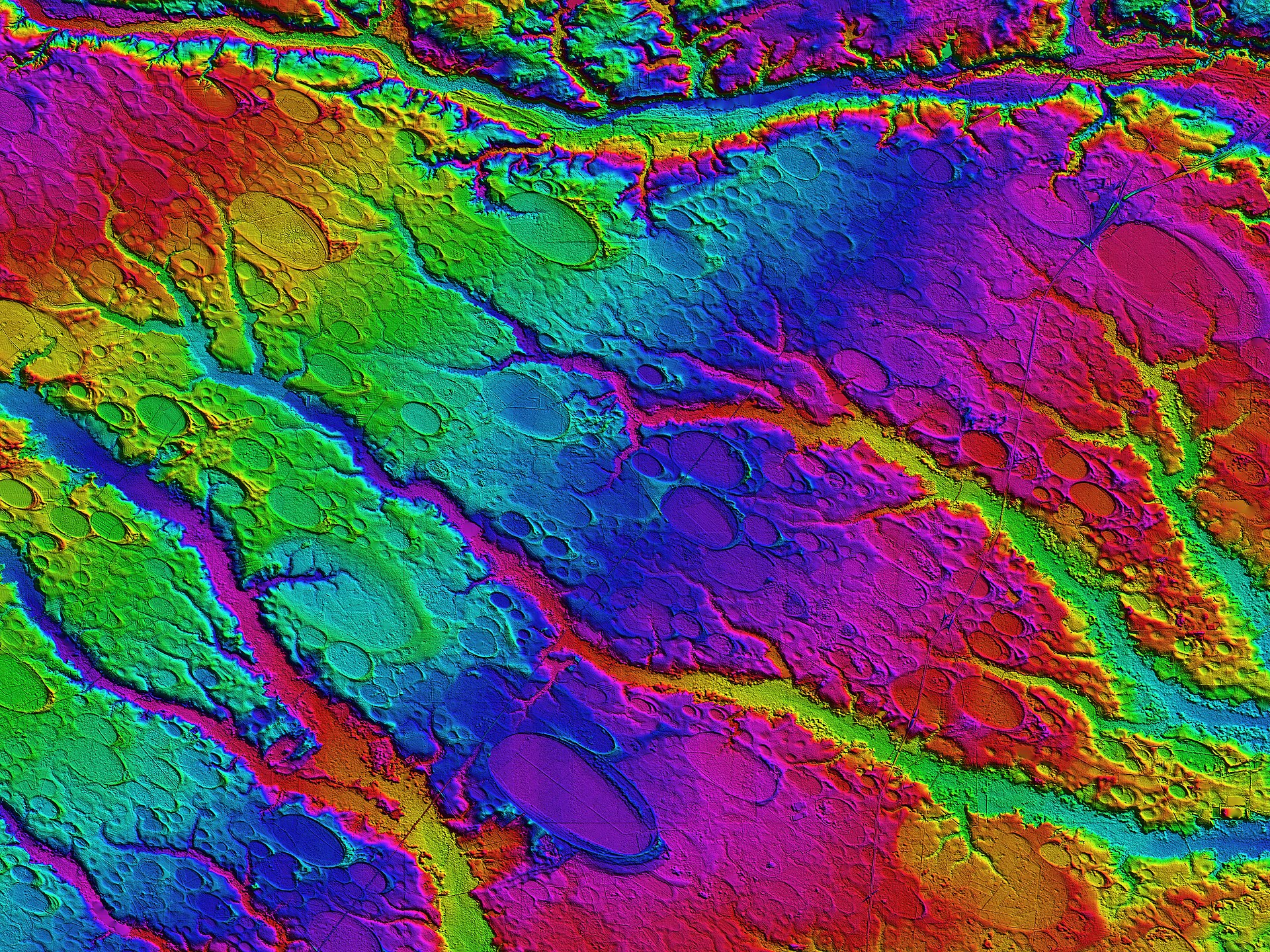
The Carolina Bays, US East Coast
Photo: Cintos (Michael Davias), USGS LiDAR data · Public domain

Strewn across the Atlantic Coastal Plain from New Jersey to Florida, the Carolina Bays are shallow, egg-shaped depressions, most with their long axes pointing consistently toward the north-west. They number in the hundreds of thousands, range from tens of metres to several kilometres across, and are often ringed by raised sandy rims. Their remarkable geometric regularity and shared orientation have made them one of North America's most persistent landscape puzzles, invoked by turns as the work of wind, water, groundwater, meteorites and comets.

See it on the globe →
The mainstream view

What archaeology says

The scientific consensus holds that the bays are terrestrial features shaped by wind and water, not scars from the sky. In this account, during colder, windier phases of the last glacial period, prevailing winds and wave action reworked shallow ponds and wetlands in the sandy coastal-plain sediments, elongating and aligning them so their long axes ran perpendicular to the dominant wind. Lakeshore processes built the sandy rims, and repeated cycles of wetting, freezing and eolian activity refined the elliptical shapes. No shocked quartz, no meteoritic fragments, no crater structure and no consistent impact-melt signature have been recovered from the bays despite extensive searching.

The strongest single argument against a common catastrophic origin is age. Optically stimulated luminescence (OSL) dating of the sandy rims, notably work led by researchers such as Christopher Moore and colleagues, returns a broad spread of ages spanning tens of thousands of years, with many bays forming and reforming long before and long after any proposed single impact date. Some rims date to well over 100,000 years ago; others are far younger. A single instantaneous event cannot produce landforms of so many different ages. Recent geomorphological modelling continues to reproduce the bays' shapes and alignments from ordinary lacustrine and eolian processes acting on a windy periglacial landscape.

Mainstream workers therefore regard the bays as a textbook case of many similar features produced by the same slow processes, misleadingly regular to the eye but unremarkable in origin.

Key evidence cited
  • OSL dates on bay rims spanning tens of thousands of years, ruling out one instantaneous event
  • No shocked quartz, meteoritic fragments, crater structures or impact melt recovered from the bays
  • Sandy rims and morphology consistent with lakeshore, wave and wind (eolian) processes
  • Geomorphological models reproducing the elliptical shapes and alignments from ordinary periglacial processes
  • Bays forming and reforming over long intervals, inconsistent with a single catastrophic origin
The alternative view

What the skeptics propose

A minority tradition has long insisted the geometry is too perfect for wind and water. The impact idea dates back to the 1930s, but its modern form came in 2007 when Richard Firestone and twenty-five co-authors proposed the Younger Dryas Impact Hypothesis, arguing that a cosmic impact or airburst over the North American ice sheet around 12,800 years ago triggered the Younger Dryas cooling, the megafaunal extinctions and the end of Clovis culture. They reported magnetic microspherules, nanodiamonds and other proxies at the boundary layer, and some proponents linked the Carolina Bays to ejecta from that event.

Engineer and independent researcher Antonio Zamora reframed the mechanism to sidestep the missing-crater problem. In his model the primary impact struck the thick Laurentide ice sheet, launching not rock but enormous chunks of ice on ballistic arcs. These icy projectiles rained down on the soft, saturated coastal-plain sediments, and rather than blasting classic craters they produced shallow, oval basins by shock liquefaction — the ground briefly behaving like a fluid and settling into elliptical scars whose orientation points back toward the launch site in the Great Lakes region. This, proponents argue, explains the alignment, the absence of meteoritic rock, and the shallow inclined geometry in one stroke.

Zamora and allied writers at outlets such as The Cosmic Tusk contend the OSL dates are unreliable for these features and can be reset or scattered, and that the convergence of the bays' long axes on a common point is the true diagnostic signature. Mainstream geologists counter that ballistic ice would not survive such flights intact, that the physics of shock liquefaction does not straightforwardly yield rimmed ellipses, and that the wide OSL age range remains the decisive obstacle.

Key evidence cited
  • Striking consistency of long-axis orientation, argued to converge on a Great Lakes source region
  • Firestone et al. (2007) reports of spherules and nanodiamonds at the Younger Dryas boundary
  • Zamora's shock-liquefaction model producing shallow ellipses without conventional craters
  • Absence of rocky meteorite debris explained as icy projectiles that melted without trace
  • Sheer number and geometric regularity argued to exceed what wind and water plausibly generate

Genuinely open questions

  1. Can any single mechanism explain both the bays' regular geometry and their very wide range of ages?
  2. Would ballistic ice ejecta survive intact flight and generate rimmed elliptical basins on impact?
  3. Are the OSL rim dates recording bay formation, or later reworking of pre-existing depressions?

Worth knowing

There are so many Carolina Bays — estimates run to half a million — that most went unnoticed from the ground for centuries; it was aerial photography in the 1930s that first revealed their haunting, shared alignment across the whole seaboard.