Catastrophe & Climate · Grand Coulee, Washington, USA

Channeled Scablands & Dry Falls, Washington

The barren, scoured landscape that proved a lone geologist right after decades of ridicule — and became the textbook case of a fringe idea that won.

Mainstream: Multiple megafloods, roughly 18,000–13,000 years agoAlternative: A single catastrophic flood around 12,800 years ago (Younger Dryas onset), in Randall Carlson's reading47.60°, -119.36°

At a glance

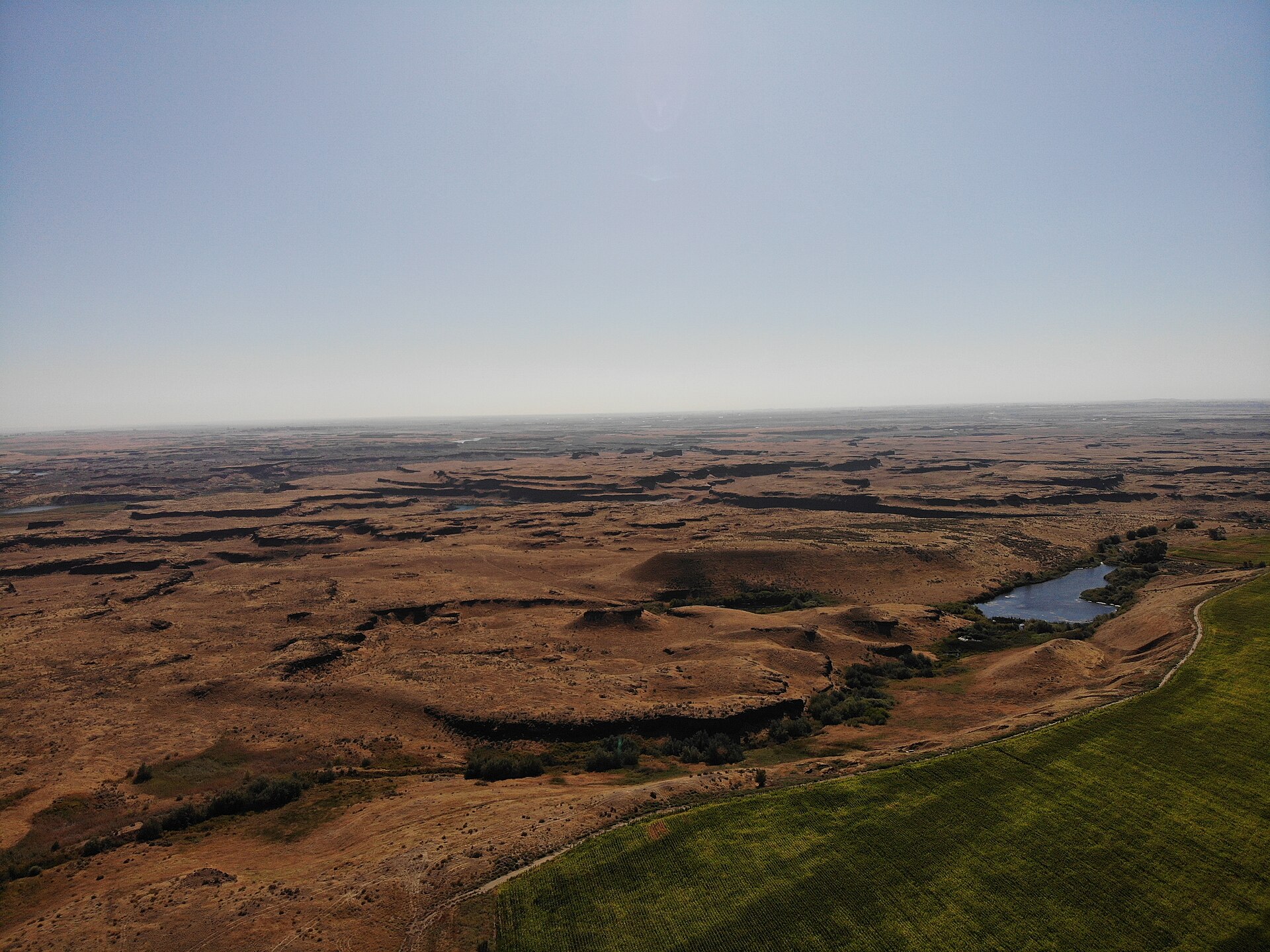
Channeled Scablands & Dry Falls, Washington
Photo: DKRKaynor · CC BY-SA 4.0

The Channeled Scablands are a vast maze of dry canyons, plunge pools and rock benches carved into the basalt of eastern Washington, stripped of soil and left as bare, scarred rock — 'scabland' was a settlers' term for ground too broken to farm. At their heart sits Dry Falls, a 5.6-kilometre cliff that was once the largest waterfall known to have existed on Earth, dwarfing Niagara, yet today no water falls over it at all. The landscape is a monument to water on an almost unimaginable scale, and to one of the great vindication stories in the history of science.

See it on the globe →
The mainstream view

What archaeology says

In the 1920s the University of Chicago geologist J Harlen Bretz argued that the Scablands could only have been carved by a sudden, catastrophic flood of staggering size. This collided head-on with the ruling doctrine of the day, uniformitarianism — the principle that landscapes are shaped by slow, everyday processes over immense time. Invoking a biblical-sounding deluge struck Bretz's peers as a betrayal of scientific method, and at a now-famous 1927 meeting of the Geological Society of Washington he was effectively ambushed and dismissed. His key missing piece was a water source. That was supplied by Joseph Pardee, who documented glacial Lake Missoula — a body of water held back in Montana by a lobe of the ice sheet — and its giant current ripples, showing the lake had drained catastrophically when its ice dam failed.

The modern consensus vindicates Bretz's mechanism but revises his single-flood picture. Beginning with Richard Waitt's work around 1980, geologists established that the ice dam formed and failed repeatedly, unleashing not one but roughly forty or more separate megafloods between about 18,000 and 13,000 years ago. Rhythmically layered flood deposits (rhythmites) with volcanic ash beds and buried soils record the successive events, and peak discharges are estimated at up to seventeen million cubic metres per second. Bretz lived to see his ideas accepted, receiving the Penrose Medal, geology's highest honour, in 1979 at the age of 96.

Bretz remains the discipline's cautionary tale about premature rejection, and his story is routinely cited whenever a maverick hypothesis meets institutional resistance.

Key evidence cited
  • Giant current ripples and drained-lake features at glacial Lake Missoula (Pardee) supplying the floodwater
  • Dry Falls and vast dry cataracts, plunge pools and scoured basalt explicable only by immense flood discharge
  • Rhythmically layered flood deposits with intervening soils and ash beds recording repeated events
  • Waitt's multiple-flood chronology dating roughly 40+ floods to about 18,000–13,000 years ago
  • Erratic boulders and gravel bars whose scale matches modelled discharges of millions of cubic metres per second
The alternative view

What the skeptics propose

The alternative community embraces Bretz as a hero — proof that the establishment can crush a correct idea for decades — and then pushes further. The best-known extended claim comes from researcher and educator Randall Carlson, popularised through the Joe Rogan podcast and Graham Hancock's work. Carlson accepts catastrophic flooding but argues the mainstream underplays both its speed and its cause. He favours a landscape shaped substantially by a single, colossal, weeks-long flood, and ties it not to the gradual retreat of the ice sheet around 15,000 years ago but to the abrupt onset of the Younger Dryas cold snap roughly 12,800 years ago.

Carlson connects this to the Younger Dryas Impact Hypothesis: the proposal that a comet or its fragments struck or airburst over the North American ice sheet, rapidly melting vast volumes of ice and triggering the floods along with continent-wide wildfires and the extinction of the megafauna. In this reading the Scablands are not merely evidence of ice-dam failures but a scar left by a cosmic catastrophe, one echoed in flood myths worldwide. Carlson emphasises the sheer erosive power on display — the plucked basalt, the giant potholes, the enormous boulders carried far from their source — as, to his eye, demanding a single overwhelming event.

Mainstream geologists respond that the layered rhythmites, the multiple ash horizons and the buried soils between flood deposits are difficult to reconcile with one event, and that the flood chronology brackets the Missoula floods well before the Younger Dryas boundary. The debate is less about whether catastrophe happened than about how many catastrophes, how fast, and what set them off.

Key evidence cited
  • Bretz's own vindication as proof the consensus wrongly rejected catastrophic flooding for decades
  • Carlson's emphasis on erosive features he reads as requiring a single overwhelming flood
  • Alignment of the flood timing, in his account, with the abrupt Younger Dryas onset ~12,800 years ago
  • Proposed link to a cosmic impact melting the ice sheet, tying floods to wildfires and megafaunal extinction
  • Global flood traditions cited as cultural memory of an end-of-Ice-Age deluge

Genuinely open questions

  1. Exactly how many distinct megafloods occurred, and can every rhythmite layer be matched to a separate event?
  2. Could any late flood pulse coincide with the Younger Dryas boundary, or do the deposits rule this out entirely?
  3. How much of the erosion was accomplished in the largest single flood versus accumulated across dozens?

Worth knowing

Dry Falls was once a waterfall roughly five times the width of Niagara and more than twice its height, over which water thundered at an estimated 105 kilometres per hour — yet today it is bone dry, a cliff over an empty gorge.