Catastrophe & Climate · North-central North America (Manitoba / Minnesota / Ontario)

Glacial Lake Agassiz

A meltwater lake bigger than all today's Great Lakes combined — whose sudden collapses may have chilled the planet and driven the sea over the world's coastlines.

Mainstream: Existed c. 13,000-8,200 years ago; catastrophic final drainage c. 8,200 years ago (the 8.2k event)Alternative: Its outbursts invoked as triggers for the Younger Dryas cold snap (c. 12,900 years ago) and, more speculatively, for global flood traditions50.50°, -96.50°

At a glance

Glacial Lake Agassiz
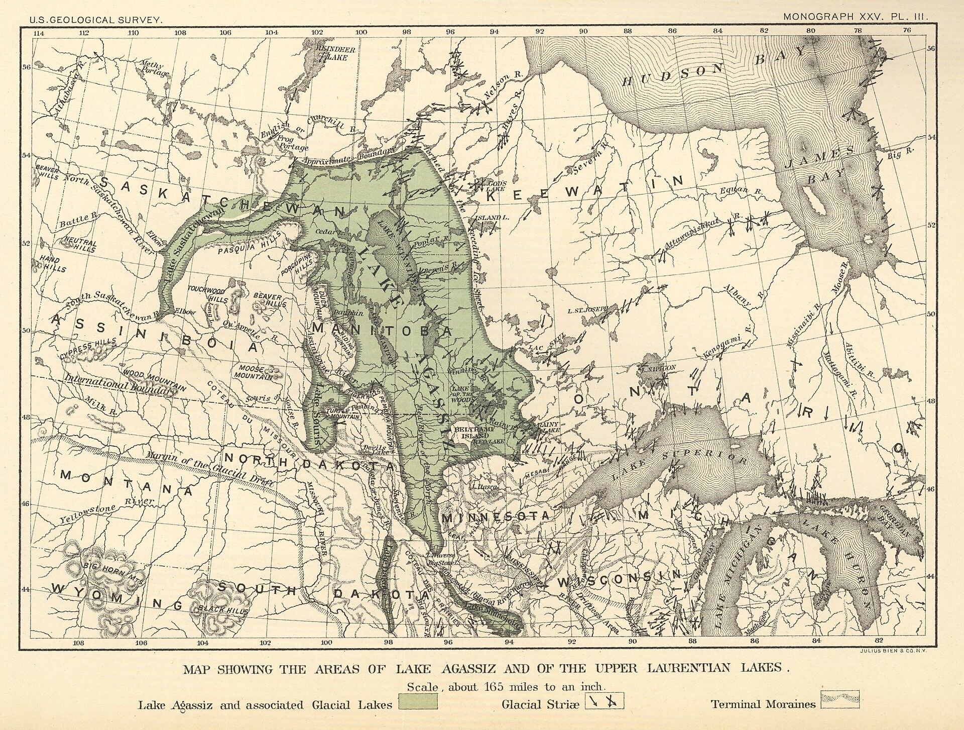
Photo: Warren Upham / USGS · Public domain

Glacial Lake Agassiz was a vast body of meltwater ponded against the retreating Laurentide Ice Sheet at the end of the last Ice Age, at times covering more than 400,000 square kilometres across what is now Manitoba, Ontario, Minnesota, North Dakota and Saskatchewan — larger than any lake on Earth today. Dammed by ice, it repeatedly filled and then burst, releasing continent-scale floods of fresh water whenever an ice barrier failed or a new outlet opened. Its most famous outbursts are suspected of having jolted global climate and nudged the world ocean upward, making Agassiz a favourite candidate for the physical reality behind cold snaps, coastal drownings and the flood memories of many peoples.

See it on the globe →
The mainstream view

What archaeology says

Geologists have mapped Lake Agassiz through its abandoned shorelines, deltas and outlet channels for over a century, beginning with Warren Upham's classic USGS survey. The lake drained catastrophically more than once as ice dams gave way and outlets switched between the Mississippi, the Great Lakes and Saint Lawrence, and the Arctic via the Mackenzie. The best-supported catastrophe is the final drainage around 8,200 years ago: as the Laurentide ice finally parted, Agassiz and neighbouring Lake Ojibway emptied into Hudson Bay in a colossal pulse, estimated at over 150,000 cubic kilometres of fresh water. This flux is widely credited with weakening the Atlantic overturning circulation and causing the '8.2 kiloyear event', a sharp century-scale cooling recorded in Greenland ice.

The lake's outbursts also contributed real, measurable sea-level rise: the 8.2k drainage alone is estimated to have raised global sea level on the order of tens of centimetres, on top of the general post-glacial rise of well over a hundred metres that was steadily submerging coastlines worldwide. Whether an earlier Agassiz outburst triggered the much larger Younger Dryas cold reversal around 12,900 years ago is more contested: the classic model routed meltwater east down the Saint Lawrence, but field workers have struggled to find that flood path, and some now favour a northwest route to the Arctic instead.

Key evidence cited
  • Mapped relict shorelines, deltas and outlet channels tracing the lake's rise and fall (Upham onward)
  • The c. 8,200-year-old final drainage of Agassiz-Ojibway into Hudson Bay, over 150,000 cubic kilometres
  • Correlation of that outburst with the 8.2k cooling event recorded in Greenland ice cores
  • Estimated tens of centimetres of near-instant global sea-level rise from the final drainage
  • Switching outlet geochemistry and sediment linking Agassiz meltwater to multiple ocean basins
The alternative view

What the skeptics propose

Agassiz sits at the centre of two big-picture arguments. The first, respectable but unresolved within science, is the Younger Dryas trigger. The idea that a sudden freshwater flood from Agassiz shut down ocean heat transport and plunged the Northern Hemisphere back into near-glacial cold for over a thousand years is elegant and influential — and it is periodically challenged both by those who cannot locate the eastern flood path and by proponents of the rival Younger Dryas impact hypothesis, who argue a comet airburst, not a meltwater pulse, did the cooling. Steelmanned, the meltwater case has the advantage of a known, enormous water source and a plausible mechanism, even if the exact spillway is still being traced.

The second, more speculative strand connects Agassiz and its Ice Age kin to the near-universal flood traditions of human cultures. Catastrophist writers point out that the terminal Pleistocene was genuinely a time of repeated, gigantic outburst floods and rapid sea-level jumps, and argue that peoples living on now-drowned coasts and river plains would have carried memories of waters that rose and never fully retreated. The mainstream reply is that Agassiz drained into Hudson Bay far from any dense human population, and that global flood myths are better explained by local rivers, tsunamis and the universal human experience of inundation. The value of Agassiz here is less as the source of any one legend than as proof that the world our ancestors inherited really was reshaped by floods of almost unimaginable scale.

Key evidence cited
  • The long-standing hypothesis that an Agassiz outburst triggered the Younger Dryas cold reversal
  • Difficulty locating the eastern Saint Lawrence flood path, keeping the trigger debate open
  • Evidence of a northwest outburst route to the Arctic offered as an alternative Younger Dryas mechanism
  • The terminal Pleistocene record of repeated continent-scale outburst floods and rapid sea-level jumps
  • Catastrophist claims that drowned coastal populations preserved these floods in deluge traditions

Genuinely open questions

  1. Which outlet did the Younger Dryas-era outburst actually take, and did meltwater alone cause that cooling?
  2. How precisely can the 8.2k sea-level and climate signals be tied to a single Agassiz drainage event?
  3. Did any human populations witness these outbursts closely enough to remember them, or did they drain into empty country?

Worth knowing

The rich black soil of the Red River Valley — some of the most productive farmland in North America — is the flat, fine-grained bed of Lake Agassiz, laid down on the floor of a vanished inland sea.