What archaeology says
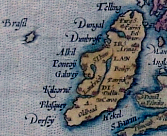
Historians of cartography read Hy-Brasil as a self-perpetuating map error dressed in borrowed mythology. Barbara Freitag's study Hy Brasil: The Metamorphosis of an Island (2013), the fullest modern treatment, argues the island began as a cartographic feature — its name probably deriving from the medieval trade word for red dye-wood or an Italian toponym, only later folk-etymologised into Irish as Ui Breasail, 'descendants of Breasal' — and that the 'ancient Celtic Elysium' framing is largely a 19th-century literary retrofit. Once Dulcert drew it, successive chartmakers copied it for five centuries, because early cartography had no mechanism for proving a remote island absent: a captain who failed to find it had simply missed it in fog. Donald S. Johnson's Phantom Islands of the Atlantic (1994) documents dozens of such copy-along islands, with Hy-Brasil merely the longest-lived.
The 'sightings' dissolve on inspection. Roderick O'Flaherty's 1684 account relays a story of a man supposedly abducted to the island and returned with healing powers; the famous 1674 landing report of Captain John Nisbet — complete with giant black rabbits and a castle-dwelling magician — was a literary hoax; and the antiquarian T. J. Westropp, who reported watching an island appear and vanish off the Clare coast in 1872, was almost certainly describing a superior mirage (Fata Morgana), an optical effect well documented off Ireland's west coast. Low cloud banks, mirages and the real but submerged Porcupine Bank — discovered by sounding in 1862, its shallowest point still some 145–200 metres under water, far too deep to have been an island even at the lowest Ice Age sea levels — jointly explain the phantom without any land at all.
- Freitag's analysis: the name and island are cartographic in origin, with the Celtic mythology attached retrospectively
- Five centuries of charts copy one another, with the island shrinking and drifting as surveys improved
- The 1674 Nisbet landing account is a demonstrated literary hoax; other sightings match Fata Morgana mirages
- Porcupine Bank's shallowest depths (roughly 145–200 metres) rule out emergence even at glacial lowstand
- Systematic Admiralty surveying in the 19th century found only open ocean, ending with deletion in 1873