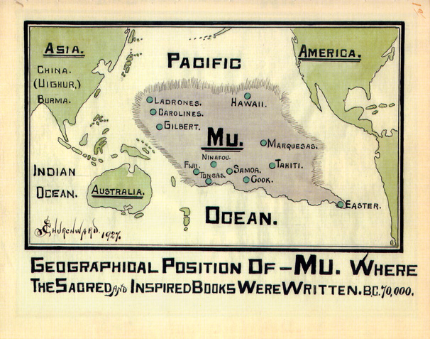
Lost Worlds · Traditional location: central Pacific Ocean (as mapped by James Churchward)

Mu (The Lost Pacific Continent)

A continent born from a mistranslated Maya manuscript — and kept afloat by tablets nobody else ever saw.

Mainstream: 1864–1931 (the idea's construction, from Brasseur's mistranslation to Churchward's books)Alternative: c. 50,000–10,000 BC (Churchward's claimed age for the civilisation of Mu)10.00°, -140.00°

At a glance

Mu (The Lost Pacific Continent)
Photo: James Churchward (1927) · Public domain

Mu is the Pacific's answer to Atlantis: a vast drowned continent supposedly home to sixty-four million people and the mother of all world civilisations. Unlike Atlantis, it has no ancient source at all. The name arose in 1864 when the French cleric Charles Étienne Brasseur de Bourbourg, using a hopelessly flawed key to Maya writing, believed he had read the story of a drowned land he called Mu in a Maya codex. The idea was embraced and embellished by the eccentric excavator Augustus Le Plongeon, then transplanted to the Pacific by the British-American writer James Churchward in a series of books beginning with The Lost Continent of Mu (1926). Plate tectonics has since rendered a sunken Pacific continent physically impossible, but Mu lives on in popular culture — and real Pacific sites such as Nan Madol and Japan's Yonaguni Monument are regularly recruited as its 'remnants'.

See it on the globe →
The mainstream view

What archaeology says

Scholars can reconstruct Mu's genealogy with unusual precision, because every link is documented and every link is broken. Brasseur de Bourbourg attempted to read the Troano manuscript (part of the Madrid Codex) using Bishop Diego de Landa's colonial-era 'alphabet' — which is not an alphabet at all, since Maya script is logosyllabic, a fact not established until Yuri Knorozov's work in the 1950s. Brasseur's 'translation', including glyphs he read as the letters M and U naming a drowned land, is gibberish; the codex is actually an almanac of astronomy, astrology and ritual. Augustus Le Plongeon, an early photographer of Yucatán ruins, built on Brasseur to produce his saga of Queen Móo of Mu, who fled the cataclysm to found Egypt — inverting real chronology, since the Maya cities he dug are millennia younger than the Egyptian civilisation they supposedly spawned. James Churchward then claimed that as a young officer in India he had been shown the 'Naacal tablets' by a temple priest, recording Mu's history in a primal language only he was taught to read. He never produced the tablets, never named the monastery, and never published verifiable translations.

Geophysics closes the case independently. The Pacific floor is young oceanic basalt, continuously created at spreading ridges and recycled into trenches; it is compositionally incapable of concealing a foundered granite continent, and bathymetric mapping shows none. Pacific islands are volcanic peaks, coral atolls and island-arc fragments, and their human settlement is recent and well understood: the Austronesian expansion and the Polynesian voyages that reached the remote Pacific mostly within the last 3,000 years. The megalithic sites claimed for Mu dissolve on inspection — Nan Madol's basalt city on Pohnpei was built from about AD 1180 by the local Saudeleur dynasty, and Yonaguni's terraces are read by most geologists as naturally fractured sandstone (see this site's entries on both).

Key evidence cited
  • Maya script is logosyllabic; Brasseur's de Landa-alphabet 'translation' that produced the name Mu is universally recognised as invalid
  • Churchward's Naacal tablets were never produced, located or independently examined by anyone
  • The Pacific floor is young oceanic crust with no continental root — a sunken continent there is geophysically impossible
  • Nan Madol is radiocarbon-dated to c. AD 1180 onward and attributed to the local Saudeleur dynasty
  • Pacific settlement is explained by the well-documented Austronesian and Polynesian expansions, with no Mu substrate in genetics or linguistics
The alternative view

What the skeptics propose

Churchward's vision, elaborated across The Lost Continent of Mu and its sequels, remains the canonical version: a continent some 9,000 kilometres across in the central Pacific, home to the enlightened, sun-worshipping Empire of the Sun, whose sixty-four million inhabitants perished around 12,000 years ago when the gas-filled chambers upholding the landmass collapsed and Mu sank in fire and water. Its colonies, he argued, became Egypt, the Maya, India and Atlantis itself, and its symbols survive worldwide — he read the rectangular glyph he called the 'M' symbol into architecture and iconography on every continent. Later writers wove Mu into esoteric systems alongside Lemuria (the two are often conflated), and the mid-twentieth-century occult revival, science fiction and Japanese popular culture gave it an enormous afterlife.

The tradition's strongest modern cards are archaeological curiosities in the Pacific itself. Nan Madol — nearly a hundred artificial islets of stacked basalt logs rising from a Micronesian lagoon, with local legends of stones flown through the air by sorcery — is exactly the kind of place Mu writers point to, and Churchward's heirs still ask how a small island chiefdom moved an estimated 750,000 tonnes of basalt. At Yonaguni, marine geologist Masaaki Kimura of the University of the Ryukyus has argued for decades that the submerged terraces are a modified or built complex drowned by rising seas, and he has explicitly framed them as possible remains of Mu. Sceptics respond that both sites are firmly dated and explicable — Nan Madol by radiocarbon to the last millennium, Yonaguni as tectonically fractured bedrock per Robert Schoch's assessment — and that a continent cannot hide from modern bathymetry. Even most alternative-history writers now treat Mu as a period piece; Graham Hancock, notably, builds his lost-civilisation case on drowned coastal shelves rather than drowned continents, tacitly conceding the geology.

Key evidence cited
  • Churchward's claimed Naacal tablets and his lifetime of asserted translations describing the Empire of the Sun
  • Le Plongeon's readings of Maya texts and murals as records of Queen Móo and the drowned motherland
  • Nan Madol's scale — some 750,000 tonnes of basalt moved by a small island population — cited as evidence of a lost Pacific capability
  • Masaaki Kimura's argument that the Yonaguni Monument is an artificial complex and a candidate remnant of Mu
  • Worldwide sun-worship and pyramid motifs read by Mu proponents as the shared inheritance of one Pacific mother culture

Genuinely open questions

  1. How exactly were Nan Madol's basalt columns quarried, transported and stacked — the engineering remains genuinely under-studied?
  2. Which features of the Yonaguni Monument, if any, show human modification of the natural sandstone?
  3. Did any real memories of post-glacial flooding of Sundaland and Pacific coastlines feed the region's drowned-land myths?

Worth knowing

The entire continent of Mu owes its name to two Maya glyphs misread as the letters M and U in a manuscript that turned out to be an astronomical almanac — arguably history's most productive typo.