Ancient Engineering · Wiltshire, England, United Kingdom

Silbury Hill & the Avebury Complex

Europe's largest prehistoric mound — a chalk pyramid with no burial, no chambers and no agreed purpose.

Mainstream: c. 2400–2300 BC (Late Neolithic)Alternative: Date not seriously disputed — alternative writers instead contest its purpose, from Michael Dames's harvest goddess to John Michell's ley-line energy centre51.42°, -1.86°

At a glance

Silbury Hill & the Avebury Complex
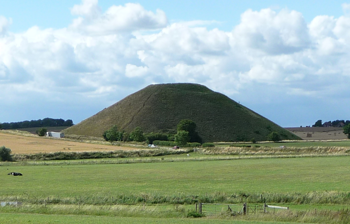
Photo: Immanuel Giel · CC BY-SA 4.0

Silbury Hill is a vast flat-topped cone of chalk rising 39.3 metres from the valley floor near Avebury in Wiltshire — the largest artificial prehistoric mound in Europe, comparable in volume to the smaller Egyptian pyramids and roughly their contemporary. Built from an estimated 248,000 cubic metres of chalk, gravel, turf and soil dug largely with antler picks, it sits at the heart of the Avebury ceremonial landscape alongside the great henge and stone circles of Avebury, the West Kennet Long Barrow, the Sanctuary and Windmill Hill, all inscribed as a UNESCO World Heritage Site with Stonehenge in 1986. Three centuries of digging into it have produced treasure of a peculiar kind: the confident knowledge that nobody knows what it was for.

See it on the globe →
The mainstream view

What archaeology says

Modern understanding of Silbury rests on the conservation project of 2007–2008, when English Heritage reopened and finally backfilled the old tunnels, allowing archaeologists Jim Leary and David Field to record the mound's interior in detail. Radiocarbon dates — including an antler fragment from the second phase dated to about 2490–2340 BC — show the mound was raised between roughly 2400 and 2300 BC, within about a century and perhaps three generations. Strikingly, it was not built to a blueprint: it grew through some fifteen episodes of enlargement, beginning with a modest gravel mound with a stake-and-sarsen kerb, then successive layers of turf, soil, chalk rubble and material from an encircling ditch that was itself repeatedly dug and buried. Leary and Field concluded the process mattered more than the product — repeated communal acts of gathering symbolically charged materials, with the final form almost incidental.

The mound's excavation history is a saga in itself: Cornish miners sank a shaft from the summit for the Duke of Northumberland in 1776; Dean John Merewether drove a tunnel to the centre in 1849; and Richard Atkinson tunnelled again in 1968–70 with the BBC broadcasting the hunt. All found the same thing — no burial, no chamber, no treasure. Neglected voids from these digs caused the summit to collapse dramatically in May 2000, prompting the 2007 rescue.

Within the wider complex, Silbury is read as one element of a Late Neolithic sacred landscape whose monuments were interlinked by sightlines and processional routes, built by the same farming communities that raised Avebury's stones — an expression of communal identity, cosmology or competitive monument-building whose specific meaning is frankly acknowledged as lost.

Key evidence cited
  • Radiocarbon dates (including antler from the mound) bracketing construction to c. 2400–2300 BC
  • The 2007–08 English Heritage investigation recording ~15 incremental construction phases
  • Antler picks, and dug chalk from the surrounding ditch, matching Neolithic technology
  • Absence of any burial or chamber despite shafts and tunnels in 1776, 1849 and 1968–70
  • Its integration with the contemporary Avebury henge, West Kennet and Sanctuary monuments
The alternative view

What the skeptics propose

Because the mound is demonstrably prehistoric, alternative theories target its meaning. The most influential is Michael Dames's, set out in The Silbury Treasure (1976) and The Avebury Cycle (1977): Silbury and its water-filled ditch together form the image of the pregnant harvest goddess seen in profile — the hill her womb — with the whole Avebury complex functioning as a cycle of seasonal ritual stations. Dames marshalled folklore (the local custom of gathering on the summit at Palm Sunday), place-names, astronomy and comparative religion, and predicted rituals at Lammas, the August harvest festival, when the first wheat was cut. Archaeologists admire the synthesis but note it is unfalsifiable and that the goddess-centred reading of Neolithic Britain has itself fallen from scholarly favour.

A second strand descends from the earth-mysteries movement. John Michell's The View Over Atlantis (1969) placed Silbury on the 'St Michael ley' and recast Alfred Watkins's old straight tracks as channels of terrestrial energy, making the hill a node in a prehistoric power grid; dowsers and researchers in his wake, including Paul Devereux, mapped sightlines in which Silbury's summit and the surrounding hills form precise visual alignments with Avebury's monuments — Devereux's careful landscape observations being taken more seriously by archaeologists than the energy claims. Sceptics respond that ley lines fail statistical tests (and the classic line does not even pass through the hill's centre), while the alignments may be real without being mystical.

Older speculations still colour the site: the legend that King Sil lies within on horseback in gold armour drove the treasure hunts of 1776 and 1849, and Moses Cotsworth around 1900 proposed the hill was a giant gnomon for calendar-keeping. Every entry into the mound has refuted the tomb theory — which alternative writers count as vindication: whatever Silbury was, it was never a grave, and its builders' intent remains as open as any question in British prehistory.

Key evidence cited
  • Dames's reading of hill-plus-moat as the pregnant harvest goddess, tied to Lammas folklore
  • Traditional gatherings on the summit recorded into the 19th century (Palm Sunday fairs)
  • Michell's placement of Silbury on the St Michael ley alignment across southern England
  • Devereux's documented sightlines linking Silbury's summit tiers to surrounding monuments
  • The mound's emptiness itself — ruling out the tomb explanation mainstream writers once favoured

Genuinely open questions

  1. What was Silbury Hill actually for, if not a tomb?
  2. Why did its builders repeatedly remodel the mound over a century rather than execute a single design?
  3. How did Silbury function within the wider Avebury landscape — processional focus, platform, or symbol?

Worth knowing

In 1968–70 the BBC televised Richard Atkinson's tunnel into Silbury hoping to reveal King Sil's golden horseman live on air — the cameras found only ancient turf, so perfectly preserved that insects and moss from 2400 BC were still identifiable.